View Larger Map
The way out of Summit County to Leadville, which would be the first stop of the day, goes over Fremont Pass. So I crossed the continental divide again, briefly falling back into the Mississippi watershed.

At the top of the pass is the Climax Mine, which intermittently operates depending on the price of steel, for they mine molybdenum there. I couldn't tell whether it was in operation today, but to give you idea of the scale of the operation, there used to be a mountain there.

On the other side of the pass lies Leadville, CO, one of my favorite towns in the country because it retains a significant amount of its old mining town character. Leadville is the highest incorporated town in the country at 10,200 feet above sea level. Needless to say, the winters can be a touch difficult, and snow is not uncommon any time of year.
I stopped at the Golden Burro for breakfast (part of why I wanted to get on the road early). The Golden Burro has never let me down on quality.
 And today would be no different. I ordered the Golden Burro-ito, which was listed as a "signature item" on the menu. And yes it was as good as it looks.
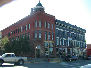
 Main street Leadville.
 Leadville has all the marks of a one-time boom town, but unlike a lot of old mine towns, Leadville clearly had aspirations on being more than a rough and tumble mining camp. The town had a population of 16,000 in the 1880s (by contrast, today's population stands at below 3000), and it is full of nicely-preserved Victorian buildings. These buildings, especially the ones on the main drag, are overwhelmingly made of stone or brick, indicating a desire for permanence, and old photos from the era show that the town had elevated, paved sidewalks (a rarity I'm sure on the frontier) and a street car that ran down Main Street.


Roaring 1880s Leadville even had its own opera house.

This is a good example of the false-front architecture you seen in most old mining towns.
 The other reason why I wanted to get an early start was that I was hoping to play 9 holes at the Mt. Massive Golf Course just outside of Leadville. They advertise as being the highest golf course in America with a course elevation of over 9600 feet. I got to the course and found that all the tee times were booked for the next couple of hours. I didn't want to wait around just to lose my balls.
Here's a pic of the course anyway. The mountain on the right is Mt. Massive, and the mountain on the left is Mt. Elbert, which is the highest peak in Colorado. As a side note, why do golfers in every part of the country all look the same?
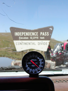
 From Leadville, I headed towards Aspen, which would take me over Independence Pass, which must be one of the highest passes in Colorado, if not the country. This would also be another crossing of the continental divide for me, taking me back in to the Pacific drainage, and this pass would also mark the highest point that I will reach on my journey.
 Here are some pics from the summit.
 The road is steep, narrow, and winding, no wonder it's closed most of the year because of snow.

 On the way down into Aspen, I came across the ghost town of Independence.

 Finally, I reached Aspen, and upon checking the local visitor center, I was directed to some National Forest campgrounds up Maroon Creek Drive. It was possible that they would already be full since they tended to fill up early, especially on weekends. I decided to chance it, and I'm glad I did. Tonight I will be camping in the shadow of the Maroon Bells, two of Colorado's 14,ooo foot peaks.
 I like the picture below because it really shows how blue the sky is here at high altitude.
 Note the beaver lodge in the foreground.
 I wish pictures could convey how pretty aspens are in a breeze. They're called quaking aspens because their leaves flutter in the slightest breeze, alternatively showing the dark top and light bottom of the leaves. I've read that this is caused by the leaf stems being flat rather than round which allows them to twist easily in the wind, and it's theorized that the reason for this is to allow these alpine trees to maximize the amount of sun they get for photosynthesis.
 My Eastern friends will note that aspens looks a lot like birch trees--at least the trunks--but I maintain that they're prettier, and if I'm not mistaken they're not actually related.
 So I was unsure about whether I would be spending one night or two in Aspen, but the decision ended up being made for me. The campground I'm staying at is completely full with pre-reserved campers starting tomorrow, so it looks like I will be moving on myself. Best guess is that I will camp somewhere near Ouray, CO tomorrow.
I can't believe you didn't have immediate cardiac arrest with that golden burro-ito.
ReplyDelete