Another day, another early morning. Today, though, the idea was to drive 500 miles, so an early start was needed. Here was today's route:
View Larger Map
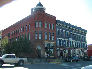
The first stop of the day was Durango, CO, where James and I ate lunch. Walking up and down the street in the historic downtown of the town, we happened across the Diamond Belle Saloon, which turned out to be an excellent choice. Irrespective of its authenticity, the place was full of old West charm.
Both James and I ordered the homemade chicken pot pie. One word: excellent.
Then the truck broke down. That's not 100% correct. The truck was making a funny noise, which I determined to be coming from the belt tensioner, so rather than have it fail in the middle of the desert miles from any civilization, we found a local shop in Durango. Charlie, the mechanic, and perhaps owner, of AA-American Auto & RV Repair, looked under the hood and confirmed my suspicions about the belt tensioner.
Here I am waiting in the shop office.
Three hours and a fair amount of money later, we were back on road, a touch behind schedule. In one way, having stopped to get the truck fixed was fortuitous because they advised us of the road conditions of the route I had planned to take. Besides being a good auto repair shop, AA-American appears to be a major towing outfit that does towing jobs all over the Four Corners area. They told us that our planned route, though paved, was rough and slow. So we remapped and headed towards Four Corners itself.
After Four Corners, we headed north into Utah.
The original plan, before the breakdown, was to make it all the way to Glen Canyon National Recreation Area just past Page, AZ to camp for the night. With our unplanned detention in Durango, however, we decided that instead we would head for Goosenecks State Park to camp. This would allow us to go through Monument Valley in the beautiful light shortly after dawn.
Goosenecks State Park sits at the edge of a remarkable canyon. The park is at place where the river makes several tight turns, so the canyon snakes through the desert here.
There was only one problem with Goosenecks State Park. It was completely misnamed. It should have been called Goosenecks Picnic Table and Overlook. We made the completely erroneous assumption that a state park would include camping (like every state park I've ever been to). Finding our plans once again confounded, we decided to push on to Kayenta, AZ, allowing us to go through Monument Valley at dusk instead of dawn, which was also gorgeous.
However, we also completely underestimated how much sunlight we had left. By the time we reached the most scenic part of the valley, the sun was already dipping below the horizon--pretty pics, nonetheless.
We arrived in Kayenta in the dark. We ate at the Blue Coffee Cafe, which we found to have a couple of traditional Navajo dishes on the menu (being in the middle of a huge Navajo Reservation, this was not entirely surprising). Both James and I indulged in the fried mutton wrapped in a tortilla. Delicious.
After eating, though, we were at a loss for where we would stay the night. We determined that camping options were extremely limited on the reservation and that there was virtually no place to stop between Kayenta and Page. We checked out a couple of hotels in the area and found them all ludicrously expensive. We pushed on to Page, where we ended up at a Motal 6, having arrived after 11pm.
The next day, we hoped, would be less...eventful, especially as we would be crossing Nevada near Area 51.
Sunday, August 30, 2009
Wednesday, August 26, 2009
Days 23 - 26 - Santa Fe, NM
Been here in Santa Fe a few days, and because I've been taking care of some errands and uncooperative weather, I haven't taken many pictures. Also, you should probably count in laziness with those reasons too. Here's what I do have.
A sunset from my dad's back porch.
Today, I drove down to Albuquerque to pick up James, who arrived early and full of ideas of how to improve the blog. He's taken me to task for using the words "beautiful" and "spectacular" too much in my descriptions of the landscape, and he insists on being my thesaurus. However, upon seeing the scale and spectacular beauty of the place, he finds himself unable to think of any better words. He's been reduced by the land to gentle murmuring and rocking in the fetal position. He may not be the help he wanted to be.
I took him to the top of the ski road here in Santa Fe, where I shot a couple of pics today.
Below, the view from near the end of the ski road, where the mountains spread and the entirety of Santa Fe comes into view several thousand feet below.
From the same spot, a couple of old couples shot our pic. In case you were wondering, James is the one without the beard.
Tomorrow we start out towards California, in a generally roundabout way. We'll head back up into Colorado before we go through Utah and Arizona. Hopefully the weather will cooperate, and I can get some good pictures of Monument Valley. Part of the reason for the backwards route is to try to stay at higher elevation to avoid the heat (James interjection: the heat, my god, the heat!), for my truck lacks air conditioning.
Sunday, August 23, 2009
Day 22 - Ridgway, CO to Santa Fe, NM
Got a late start today because a post-breakfast soak at the hot springs was in order. Nevertheless, the drive was extraordinary. Here was today's route:
View Larger Map
The first stop was Ouray, CO. Like Leadville, it's an old mining town that retains a significant amount of its old mine town look. These Colorado mine towns have an undeniable charm.
After Ouray, it was south over U.S. route 550, nicknamed the Million Dollar Highway. I always heard that the name derives from the fact that the highway cost a million dollars per mile to build in the 1920s. Wikipedia claims that another theory of the naming is that the dirt fill under the highway contains a million dollars of gold ore. Whatever the actual reason, the drive is simply spectacular. It is the proverbial mountain road with thousand foot cliffs on either side and no guardrail. I would recommend the drive to anyone, unless, of course, you're deathly afraid of heights, and even then, just look at the uphill side.
The top of the pass south of Ouray is at Red Mountain, where the mountains truly are red and dozens of derelict mines scar the mountainsides.
South of the pass, I dropped into Silverton, CO, another classic Colorado mine town. Silverton is perhaps the most authentic appearing of all the old mine towns I've been to in Colorado, that is if you don't pay too much attention to what's in the stores. Tourist traps are all the same no matter where you are. But adding to the authenticity is that only the main thoroughfare in town is paved. Below is the county courthouse.
And city hall.
Here is the main thoroughfare.
A typical street scene.
Silverton is the terminus of the Durango & Silverton narrow guage railroad. I didn't ride it this time, having done it before, but it is a beautiful ride through the mountains along the Animas River. The train uses historic, coal-burning locomotives.
From Silverton, I headed south into New Mexico. I decided to take the long way around to Santa Fe by going through Taos. It's a rather scenic drive, but because of storms across the pass, I didn't stop to take pics. However, just before getting to Taos, the road descends into the Rio Grande valley. And suddenly, without warning--that is to say you can't see it until you're right on top of it--a deep gorge cut by the Rio Grande itself appears.
I arrived in Santa Fe after dark so no pics of the area, but I'll be here for a few days. My friend James will be joining me here Wednesday for the final push into California. I may not update the blog each day I'm here, but I will put up some pics of Santa Fe at some point during my stay. Once James arrives, the next leg will take us back into Colorado briefly, then Utah and Arizona.
Friday, August 21, 2009
Day 21 - Silver Bell Campground, near Aspen, CO to Ridgway, CO
Today was another not terribly long day, but for as short as it was, it was incredibly scenic. The drive between Carbondale and Delta was over a steep, narrow, winding road that was simply beautiful. But because of the nature of the road, there simply weren't places to turn off to take pictures at the scenic spots. Here was today's route:
View Larger Map
My first stop was Black Canyon of the Gunnison National Park--as a side note, that annual national parks pass I bought is really paying off. I'm not 100% satisfied with the photos. My camera doesn't really like dark/bright contrast. Anyway, the canyon is quite spectacular, being over 2000 feet deep and very narrow.
I'm camping near Ridgway, CO. I had probably the best burger of my trip here at the Union Cafe.
Ridgway is a rather cute little town at the foot of the San Juan Mountains.
In the middle of town is a nice green.
What appears to be dead trees in the park are actually sculptures. This is the cutest of the bunch.
Not sure if I'll stay here one or two nights, so we'll see what happens tomorrow.
Thursday, August 20, 2009
Day 20 - Summit County, CO to Silver Bell Campground, near Aspen, CO
Another day, another early morning. Today, though, it was purposeful. I wanted to get on the road, though I didn't have far to travel. The reason for doing so would become moot, as you'll see below. Here was today's route:
View Larger Map
The way out of Summit County to Leadville, which would be the first stop of the day, goes over Fremont Pass. So I crossed the continental divide again, briefly falling back into the Mississippi watershed.
At the top of the pass is the Climax Mine, which intermittently operates depending on the price of steel, for they mine molybdenum there. I couldn't tell whether it was in operation today, but to give you idea of the scale of the operation, there used to be a mountain there.
On the other side of the pass lies Leadville, CO, one of my favorite towns in the country because it retains a significant amount of its old mining town character. Leadville is the highest incorporated town in the country at 10,200 feet above sea level. Needless to say, the winters can be a touch difficult, and snow is not uncommon any time of year.
I stopped at the Golden Burro for breakfast (part of why I wanted to get on the road early). The Golden Burro has never let me down on quality.
And today would be no different. I ordered the Golden Burro-ito, which was listed as a "signature item" on the menu. And yes it was as good as it looks.
Main street Leadville.
Leadville has all the marks of a one-time boom town, but unlike a lot of old mine towns, Leadville clearly had aspirations on being more than a rough and tumble mining camp. The town had a population of 16,000 in the 1880s (by contrast, today's population stands at below 3000), and it is full of nicely-preserved Victorian buildings. These buildings, especially the ones on the main drag, are overwhelmingly made of stone or brick, indicating a desire for permanence, and old photos from the era show that the town had elevated, paved sidewalks (a rarity I'm sure on the frontier) and a street car that ran down Main Street.
Roaring 1880s Leadville even had its own opera house.
This is a good example of the false-front architecture you seen in most old mining towns.
The other reason why I wanted to get an early start was that I was hoping to play 9 holes at the Mt. Massive Golf Course just outside of Leadville. They advertise as being the highest golf course in America with a course elevation of over 9600 feet. I got to the course and found that all the tee times were booked for the next couple of hours. I didn't want to wait around just to lose my balls.
Here's a pic of the course anyway. The mountain on the right is Mt. Massive, and the mountain on the left is Mt. Elbert, which is the highest peak in Colorado. As a side note, why do golfers in every part of the country all look the same?
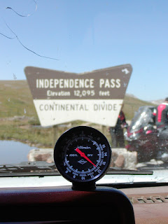
From Leadville, I headed towards Aspen, which would take me over Independence Pass, which must be one of the highest passes in Colorado, if not the country. This would also be another crossing of the continental divide for me, taking me back in to the Pacific drainage, and this pass would also mark the highest point that I will reach on my journey.
Here are some pics from the summit.
The road is steep, narrow, and winding, no wonder it's closed most of the year because of snow.
On the way down into Aspen, I came across the ghost town of Independence.
Finally, I reached Aspen, and upon checking the local visitor center, I was directed to some National Forest campgrounds up Maroon Creek Drive. It was possible that they would already be full since they tended to fill up early, especially on weekends. I decided to chance it, and I'm glad I did. Tonight I will be camping in the shadow of the Maroon Bells, two of Colorado's 14,ooo foot peaks.
I like the picture below because it really shows how blue the sky is here at high altitude.
Note the beaver lodge in the foreground.
I wish pictures could convey how pretty aspens are in a breeze. They're called quaking aspens because their leaves flutter in the slightest breeze, alternatively showing the dark top and light bottom of the leaves. I've read that this is caused by the leaf stems being flat rather than round which allows them to twist easily in the wind, and it's theorized that the reason for this is to allow these alpine trees to maximize the amount of sun they get for photosynthesis.
My Eastern friends will note that aspens looks a lot like birch trees--at least the trunks--but I maintain that they're prettier, and if I'm not mistaken they're not actually related.
So I was unsure about whether I would be spending one night or two in Aspen, but the decision ended up being made for me. The campground I'm staying at is completely full with pre-reserved campers starting tomorrow, so it looks like I will be moving on myself. Best guess is that I will camp somewhere near Ouray, CO tomorrow.
Subscribe to:
Posts (Atom)